I'd
started planning this trip a while ago, then things happened. The
firm I've been working for, for the last eight or nine years, went
bust. I wasn't employed directly by them, I worked for an agency, so
theoretically the agency should have moved me to another firm. Only
they didn't have any other clients. All of a sudden I was getting the
odd shift here and there, maybe one a week maybe none. Then I had a
fall skiing at Cairngorm mountain, I broke a bone in my ankle and my
knee partially dislocated before popping back in, as it did this the
ligaments holding my knee cap in place were sprained and twisted. It
hurt like hell but A&E said there wasn't much they could do, a
plaster cast wouldn't help as the brake was inside the joint. They
said it should heal in four to six weeks on it's own. As I wasn't
getting any work there wasn't much need to take time off, so I sat
around trying to rest my leg getting more and more bored. After three
weeks I started doing some short walks around the local area. Then
some longer walks to nearby villages and finally I went up Ben Lawers
with a rucksack packed for a weekend out. The leg seemed OK. I rang
the agency and told them I was going away for a week. I went online
and booked two bus journeys one to Aviemore and one back from Fort
William, both on my bus pass so they cost me nothing. I packed nine
days food and my kit, then went out for a walk. I hadn't gone far
when the phone rang, it was John Marshall's a firm I'd done a little
work for in the past and had sent a CV to purely on spec. “We're
looking for drivers can you come in and see us.” Yes of course I
could. I went in next day and they offered me a job. I said I had to
work a weeks notice just so I could still get my walk in.
I
got the 08.10 bus into Stirling where I had to wait half an hour for
the City-link to Perth, here I waited another twenty minutes for the
bus to Inverness which stopped at Aviemore. At 13.15 I arrived
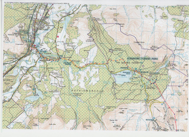
outside the train station in Aviemore. My route took me along the
“Old logger's way” to Glenmore village. On the journey up it had
been showery and very overcast but as I walked along the sun came out
and it got quite warm. I popped into the Red Squirrel Cafe for a last
pot of tea and a cake before wandering into the forest above the
village. It took me a while to find the right track, and the faint
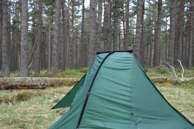
footpath I wanted. Then a while longer to find somewhere to camp. I
eventually settled on a stand of old Caledonian Pines, still a
plantation but at least the right type of tree. I'd taken some
different types of dried food along so I could check them out, I
pulled out a “Firepot” Dall and Rice with Spinach. Sounded good
but turned out to be rice and wood chips in a water curry sauce. The
three bits of green tissue paper one inch by a quarter inch were
apparently the spinach. I didn't eat much of it. I turned in
listening to bird song. I woke to the sound of bird song and a
woodpecker drilling.

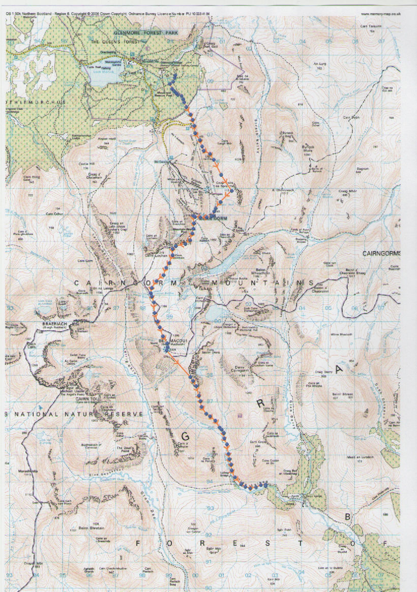
After
a very cold night I was slow getting going and didn't leave till
after eight. The path which followed the Allt na Ciste was overgrown
and obviously little used these days, clearly most people just drive
up to the ski centre car park. It was steep as well, climbing a
thousand meters in under six kilometers. I broke out of the trees
just below the old Coire na Ciste car park, the chairlift bottom
station now covered in graffiti abandoned and forlorn. As I climbed
higher it started to rain and the clagg descended, I plod on seeing
little. Odd landmarks come and go keeping me on track. Coire Laogh
Mor to me left, a nice off piste ski run when there's some snow,
Coire na Ciste to my right. I crest the ridge by Cnap Coire na
Spreidhe and the top of Ciste Mhearad another off piste run that will
take you down to Loch Avon. Then the top of a ski tow looms out of
the mist, the plateau poma, I find the start of the rather
over-engineered path just beyond it that takes me to the summit of
Cairngorm. It's 13.00 already, I stop for a biscuit by the summit
cairn. There's another walker there, he's moaning about the weather,
how far he's walked, the roughness of the ground and half a dozen
other things. I smile but thing to myself. “Well you're a cheerful
fellow, aren't you”. I set the compass due west and set off down
the steep scree slope. Oow the ankle doesn't like that, not one bit.
I limp on down as best I could. Then I come to a big snow patch and
kick steeps down it but it turns hard so I get onto the side and
continue on down. Then I realize the aspect has subtly changed and
I've gone down too far, I climb back and soon find the giant cairn
that marks the top of the Fiacaill ridge.
Now
I'm on a Cairned Path and can relax a little. I meet a woman and a
child then a dog, on it's own, it runs off. Further along I meet a
couple who ask if the dog was mine. I tell them, no. I climb up to
the summit of Stob Coire an t-Sneachda and down the other side. At
the col at the head of Coire Domhirn just before the path starts to
climb up to Cairn Lochan, and a couple of kilometres from where I'd
last seen the dog. I find the owners, “Oh don't worry about her”
they say “she's always running off”. The path up Cairn Lochan
would take me further around the rim of the “Northern Coirres”
another path heads off south to the Lochan Buidhe, I take this. It
soon disappears under a snow patch and I can't see the other side in
the mist. I take a compass bearing and plod on. Then I meet two
girls, Irish, mid-teens. Their wearing what to anyone who grew up in
the sixties are school plimsolls, only these are coloured, leggings
and none waterproof coats which are soaked. They both looked frozen.
“Er, excuse me, is this the path back to the car park?” they ask.
I groaned inwardly, what should I do now? I think I should see them
off the mountain safely. But that would seriously screw up my plans,
I was later enough as it was. I gave them directions back to the
cairned path. “Are you sure you'll be OK” I asked feeling guilty.
“Oh yes” they say.

At
the Lochan Buidhe I pick up the main path to Ben Macdui, more of a
motorway than a path. There 's hundreds of oversized cairns marking
the way, even in this mist I can always see several at any one time.
The wind had been getting stronger all day and was now enough to make
standing still difficult, it was also getting really cold. I had my
thin fleece gloves and beany hat on but was beginning to wish I'd
brought my mitts and warm hat with me. There was not much I could do
about it except push on. Eventually the slope flattened out and stone
shelters began to appear, then finally the summit trig point. It was
16.00 how had it got so late? Why was I going so slow? No time to
ponder these questions, I needed to get on. I tried to take a compass
bearing but my hands were too cold, I couldn't grip the bezel. So,
I'm on top of a mountain in a howling gale shaking my hands, flapping
my arms and dancing a little gig just to warm up my hands enough to
work my compass. Oh great, good job there's no one around to see.

Eventually
after much faffing about I get a bearing set for Sron Riach a couple
of kilometers away and head off. First I drop down then cross a
boulder field before climbing a bit, then I approach the top of a
huge Craig off to my left, all going according to the script. To my
right the ground slopes away less steeply and my way becomes a narrow
ridge as expected. I drop down a bit more to a col and then a window
in the clouds opens up before me. Then I have a major “Where the
hell am I!!” moment. I can see two huge steep sided mountains their
sides all glacier polished slabs, water pouring off in torrents. It
looked like the Gates of Mordor, certainly nowhere I recognized. I
sat on the ground mortified, I kept staring at the map but I was
baffled. Eventually, I got out my phone, switched it on, turned
Viewranger on only for it to confirm I was where I should be, on Sron
Riach. But what was I looking at? Where were the gates of Mordor?
Then it clicked, they were much further away than I thought, way off
over the other side of the Lairig Ghru. They were The Devils Point
and Beinn Bhrotain over ten kilometers away.

After
I'd picked myself up, I headed off down the long ridge of Sron Riach
in the direction of the Luibeg Burn. By now the ankle was really
complaining and the knee wasn't much better. I had a memory of
camping at the foot of this ridge with an old girlfriend about twenty
years ago. How the memory plays tricks on you. The whole area is now
overgrown with waist high Heather, I could see nowhere to put a tent
and even if I could have the ground was far too boggy. I pushed on, I
looked at several places all to no avail. I was half way between
Luibeg Bridge and Derry Lodge where the Burn takes a bend before I
found somewhere for the night. Where there were a couple of blown
down trees by the side of the burn there was a small patch of short
flat grass. By the time I had the tent up and fetched water it was
20.00, I decided to stick with the tried and tested Bewell meal this
time.

It
was a very very cold night, I wished I brought my warmer sleeping bag
and more clothes. The ankle and knee hurting all night didn't help. I
felt very groggy next morning and was even slower to get going than
the day before, something unheard of for me. As I retraced my steeps
back to the Luibeg bridge I was past my a young couple on mountain
bikes, then they'd stop for a rest and I'd pass them. This happened a
few times, when I reached the bridge they were just behind me. I
thought they'd soon catch me up but they didn't catch me till I was
almost at Corrour. So much for mountain bikes being quicker. After
the bridge as I approached the start of the Lairig Ghru I could for
the first time look directly into Glen Geusachan which lies between
Beinn Bhrotain and the Devils Point. My plan was to cross the River
Dee here and explore this Glen as I'd not been into it before. But, I
could now see that it contained some very rough terrain and there
wasn't any hint of a path. Time for a rethink.


The
plan had been to camp near Loch nan Stuirteag which is behind (west
of) The Devils Point but I could also get there by going the other
way around the mountain. If I went up the Lairig Ghru to Corrour I
could use the bridge so avoiding the river crossing and there's a
path up that side. So that's what I did. Glen Geusachan will just
have to wait. I poked my head around the door at Corrour but
unusually there was no one there. By now the wind had died and the
sun put in a brief appearance so I sat outside and enjoyed my
biscuit. I even went so far as to take off my windproof top, it
didn't stay off long. The climb up into Coire Odher is steep, 600m in
one kilometer. It starts steep, levels out for a while as you enter
the coire then the headwall is very steep. Right at the top was a
patch of snow not very wide but enough to spice things up a bit.
Eventually, breathless and tired, I arrived at the ridge above with
The Devil's Point on one side and Stob Coire an t-Saighdeir and Cairn
Toul on the other. Now I should have gone over Stob Coire an
t-Saighdeir, which is really just a shoulder of Cairn Toul, but I was
lazy and decided to contour around instead, big mistake. It would
have been far easier to have gone over as contouring was far further
and the going was rough on a constant side slope. Once I could see
the loch I could see that all the ground around it was waterlogged
and not good for camping. Fortunately, I knew of a place nearby.
Draining the south west side of Cairn Toul is a stream, the Allt
clais an t-Sabhail along it's length are a few nice places for a tent
or two.

At
around 1000m it was a cold spot, I quickly rapped up in all my spare
cloths and retreated into the tent. So, what to do next? I just
wasn't romping along at my normal pace, I'd only covered half the
distance I'd planned and the pain from my ankle was really spoiling
the fun. It wasn't that I wasn't enjoying being there, just that the
pain was getting tiring. The next section getting to Drumochter was
going to be tough, with lots of untracked heather moor to cover. At
my present pace it was becoming clear that I wouldn't get to Fort
William in seven days. If I carried on I could get stuck between bus
routes with no easy way of getting home. On the other hand if I went
over Braeriach and down into the Lairig Ghru. I could be back in
Aviemore by tomorrow evening but that would cut my holiday very
short. I wasn't that ready to throw in the towel just yet. I played
around with various options in my head, going this way and that but
all routes had snags. The stream I was camped beside, and Loch nan
Stuireag, both drained down Glen Geusachan and into the Dee. But,
just one kilometer west of the Loch another stream drains away to the
south west down a short gorge. As it emerges from the gorge it turns
south and becomes the River Eidart. This really is a beautiful glen
and something of a hidden gem. I could follow the Eidart to it's
confluence with the Feshie and then follow that to Achlean farm.
Trouble was, how to avoid the long road walk from there to
Feshiebridge and the forest tracks to Aviemore.


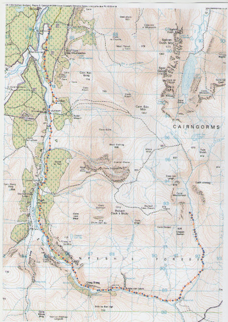
Frost
on the inside of the tent didn't encourage an early start but, once
up, the morning sunshine soon dried the tent. It was turning out to
be a beautiful warm and sunny day and it seemed a pity to be heading
home. I took a roundabout route sticking to old moraines and rocky
ground to stay dry. Just before Tom Dubh I had to cross a section of
peat bogs to get to the start of the gorge. A sharp alarm call and
movement in the grass caught my attention. A pair of small waders
were defiantly defending their nest site. I backed off, changed to my
telephoto lens and took a few shots of the birds before finding
another way around them. I didn't know what they were but later found
out they were Dunlin. The scramble down into and along the gorge
wasn't kind on the ankle but it's such a dramatic place I really
didn't mind the pain. After the gorge I sat in the sun and enjoyed a
prolonged lunch stop to recover. The river with it's numerous falls
and pools should be ideal territory for Northern Dippers but so far I
hadn't seen any. I kept to the riverside looking for them until after
only about three kilometers I came to wide grassy area and just
thought to myself. “I'm stopping here, it's just so nice”. It was
only mid-afternoon but I wasn't bothered. I found a nice rock to sit
on and put the tent up right beside it. I sat on my rock drinking
tea, reading and chillin for a few hours until a cool wind drove me
into the tent. I continued reading “High and Low-how I hiked away
from depression.” by Keith Foskett. Not the lightest of reads. At
one point I had to go out of the tent to pee. I looked around and
right above me was a Golden Eagle riding the thermals. Too high to
photograph unfortunately.

The
down side of camping on the west side of a deep valley is you loose
the sun early. The upside is you get the sun early next morning. It
had been yet another very cold night so the warmth of the early
morning sun was especially welcome. I was breakfasted and pack by
seven. I stuck to the river still looking for Dippers. I'd gone about
a couple of kilometers when I finally saw what I'd been looking for.
A brief blur of movement, a splash, and it was gone. I spent nearly
an hour trying to get a photo, but no luck. I'd just put away the
telephoto when the Golden Eagle returned flying right overhead at
about fifty feet. “C'est la vie.”


Someone
from the estate had been up Glen Feshie as far as Eidart Bridge in an
ATV recently, the tracks had churned up the ground and left quite a
mess. This didn't make for easy walking and it wasn't until I hit the
gravel road that things improved. By this time I was having to stop
and rest my ankle ever half hour or so. I stopped at Ruigh Aiteachain
Bothy just for a nosy around as it's been done up recently. It's now
really posh, far too posh for walker. I'd not seen anyone for a
couple of day by this time but two minutes after I'd entered the
bothy I hear voices outside. A couple had just walked in from Achlean
to spend the afternoon painting. They tell me about the bothy and
it's association with Sir Edwin Landseer and his painting “The
Monarch of the Glen.” Not far from the bothy is a chimney standing
on it's own with no building attached to it anymore. This is all that
remains of Sir Edwin's private bothy which was a wooden building. He
stayed at his bothy when he painted the Monarch. As it was only
mid-afternoon I pushed on to Achlean and started the long slog down
the road. I'd sort of decided that I'd walk as far as Balachroick.
The old bunkhouse is only let out to group bookings these days but I
knew just beyond it there are places to camp in the wood. I'd just
reached the bunkhouse when a car pulled up beside me. It was the
couple from the bothy, they gave me a lift to Aviemore. I stayed at
the SYHA that night and got the bus home the next day.


Great stuff Owen! That's a big route on a recently injured knee and ankle, hope both make a full recovery in time. The Eidart is a wild wee river, just lovely. Really enjoyed this longer post too
ReplyDeleteIan